Hiking the Müllerthal Trail, Luxembourg
In October, Caroline and I hiked the 112-kilometer (70-mile) Müllerthal Trail in Luxembourg’s Little Switzerland.
By doing so I checked off one of my main goals for this year: completing a long-distance hike.
Although it is definitely one of Europe’s less known long-distance hiking trails—I, myself, didn’t even know it until a week or two before we did it—the Müllerthal Trail boasts the quality label “Leading Quality Trails – Best of Europe”, a status that is granted by the European Ramblers’ Association.
Because I absolutely loved this trail, even though the weather was super-cold, I want to dedicate a detailed and photo-filled blog post to it.
The Müllerthal Trail runs through the heart of the namesake Müllerthal region in the east of Luxembourg, also known as Luxembourg’s Little Switzerland. The 112-kilometer (70-mile) trail consists of three loop trails that connect in two places, thus creating a trail shaped like a double 8.
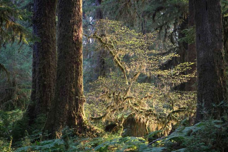
Each of those three trails has its own distinct character, as you will see in more detail below. Route 1 offers the perfect introduction to the region, leading across farmlands, through dense woods and past formidable rock formations. Route 2 takes hikers right into the very heart of Luxembourg’s Little Switzerland and to imposing rock cliffs, ravines, lush forests, and waterfalls and streams. Route 3 runs past spectacular medieval castles, along rivers and past boulders.
The Müllerthal Trail is characterized by the fact that it combines many different aspects of Luxembourgish life and runs through virtually all of the country’s landscapes—from tall rock formations and moss-covered boulders to romantic castles and cow-dotted meadows. The medieval town of Echternach, in addition, is a major highlight as well, a former pilgrim’s destination and famous for its “Dancing Procession”, which is listed as Intangible Cultural Heritage of Humanity by UNESCO.
Hiking the Müllerthal Trail in Luxembourg’s Little Switzerland
Route 1 (38 kilometers (23.5 miles))
The obvious starting point for Route 1 and the Müllerthal Trail is Echternach, by far the biggest town in the region and the hub of transportation.


The first section of Route 1 runs through the town of Rosport, home to the beautiful Tudor House, before continuing to Gisterklaus and its ancient pilgrimage chapel. Already, this section reveals the beauty of this region, the trail passing underneath impressive rock formations and running across extensive meadows and fields. Section one of Route 1 ends at a campsite on the banks of the Sûre River.
Echternach – Rosport – Born: ± 16 kilometers (10 miles) in 5.5 hours


The second section of Route 1 took us from the campsite in Born up to a plateau of farmlands, and then onward to the forest of Herborn and the lake of Echternach. This section of open woods and scenic farmlands took us 7 hours to complete.
Born – Herborn – Echternach: ± 22 kilometers (13.6 miles) in 7 hours


More hiking: Hadrian’s Wall Path – A Hike Along History
Route 2 (37 kilometers (23 miles))
Echternach was also our starting point for Route 2, which we also hiked in a clockwise direction. From the Echternach bus station, the Müllerthal Trail climbs steeply up a hill, offering great views down of the town. The first part of Route 2 runs through beautiful woods to the small town of Scheidgen. After bisecting the town, the trail then passes a series of amazing rock formations bearing names such as Härgottskap, Einsiedelei and Daxelay. Further up the trail, we passed an old cave that used to be the home of a hermit called Michel—the cave is known as Mëchelskirch.


That first section of Route 2 (leg 3 of the Müllerthal Trail) alternates between forests and open farmlands. Before ending in the town of Consdorf, the trail again enters the woods and runs past fabulous cliffs and through ravines, including the incredibly narrow Kohlscheuer canyon and the Déiwepëtz and Rittergang crevices.
Echternach – Scheidgen – Consdorf: ± 20 kilometers (12.4 miles) in 7 hours and 15 minutes


On day four, the Müllerthal Trail was at its most spectacular, leading us past many more rock formations—Goldkaul, Goldfralay and Eileburg—the fairy tale-like Schiessentümpel waterfall, through Müllerthal village and along the Black Ernz brook.


More rock formations await all along the second leg of Route 2, including the Predigtstuhl, Binzelschlüff and Roibackschlüff. This landscape of dark caves, massive cliffs, canyons and lush mossy woods seems to come straight out of the Lord of the Rings—yes, I’m a huge fan.
The last section of Route 2 leads past the enormous boulders of Perekop, a rock formation with ladders that can be climbed. Next up is the Labyrinth, after which the trail follows a deep and steep crevice known as the Wolves’ Canyon, a sheltered ravine where wolves used to live. Route 2 ends with a fantastic view of Echternach.
Consdorf – Müllerthal – Echternach: ± 17 kilometers (10.5 miles) in 5 hours and 50 minutes


More hiking: 15 Long-Distances Hikes of Less Than One Month
Route 3 (38 kilometers (23.5 miles))
After using Echternach as a starting point twice, we approached Route 3 a little differently. We set up camp in a cabin at a campsite in Larochette and took buses to and from the trailheads—the bus network in Luxembourg is fantastic, by the way.


So, our first section of Route 3 started at the bus station in the tiny village of Blumenthal. After climbing into the woods, the Müllerthal Trail quickly hits a couple of highlights—an old sundial that has been chiseled into a rock on top of a cliff and the small but beautiful Ripsmoor marsh. The trail then descends again into Müllerthal village and passes the Schiessentümpel waterfall once more—this is where Route 2 and Route 3 intersect.
The next part of Route 3 runs through a gorgeous valley for several kilometers, the Müllerthal following a small stream and crossing it many times via pretty wooden bridges. Made up of vine-covered trees and mossy rocks, this is a magnificent, even enchanting, landscape. This section ends the spectacular ruins of Beaufort Castle.
Blumenthal – Müllerthal – Beaufort: ± 17 kilometers (10.5 miles) in 4 hours and 50 minutes


The last section of Route 3, and the Müllerthal Trail as a whole, begins again at Beaufort Castle. On the way to Larochette, the trail runs across open fields and through enclosed forests. Occasionally, on stretches across those farmlands, wide and far views invite hikers to take a break on one of the many trailside benches. The major highlight on this section is a couple of lookout points offering amazing views of the town of Larochette that is dominated by the vast ruins of Larochette Castle.
This section ends after following a stream for a while, offering a couple of expansive views and running, again, through patches of woodland.
Beaufort – Larochette – Blumenthal: ± 21 kilometers (13 miles) in 5 hours and 30 minutes


There is a plethora of campsites in Luxembourg’s Little Switzerland and hiking the Müllerthal Trail can, as such, be done with a backpack and tent. If you want to do that, though, make sure to buy food whenever you can—we counted on buying food in the towns on the way, but quickly found out that most of those small towns do not have grocery stores.
Another way to approach the Müllerthal Trail is setting up camp in one place—a hostel, B&B or campground like the excellent Camping Auf Kengert in Larochette—and using public transportation to get to the trailheads and back again. The bus network is dense and works extremely well.
It took us six days to complete this magnificent trail, six days that, I have to admit, were rather cold. I would suggest hiking the Müllerthal Trail from May through September.
You can buy a large detailed hiking map as well as a Müllerthal Trail pocket guide in the tourist office in Echternach, located right in front of the basilica.


What a wonderful post! I am a huge fan of long distance hikes. This is also the first time I hear about this trail in Luxemburg. First of all, I would never expect that in such a tiny country there are so many long trails. Further, the landscape is captivating! I wouldn’t mind walking it, even in a bad weather. Thanks for letting us know about it!
Thanks, Agata! I definitely recommend this trail, especially because it’s so unknown and quiet. 🙂
I never think of long distance hiking and Luxembourg but this trail looks like a beaut. Great photos – looks like some chilly camping though.
Yeah, I was really pleased that I came across this hike and had the opportunity to actually do it. I’m trying to spread the word now, it’s a great hike.
Hi which was your favorite trail if we only have 2 days to hike?
Thanks, Amy
Hi Amy! That would definitely be Route 2. This is the longest of the three routes, but by far the most spectacular.
Is Route 1 doable in one day for a fit person? How many hours would it take, including breaks?
Fulvio, Route 1 is 38 kilometers long, which would be a challenge if you wanted to do that in just one day. It’s not impossible, though, but I would count on 15 hours to complete that loop, including short occasional breaks.
Hi, I’m thinking of doing 2 Stages over 2 days using Echternact as a base and returning by bus after completing a Stage.
I see you recommend Route 2 as the most spectacular, but which individual stages would you recommend out of Route 1 and 2?
For example, would you recommend spending a day doing a stage from Route 1 and a day doing a Stage from Route 2? Or do you think spending two days doing Route 2 would be better?
Thanks
Hi Andy,
Thanks for your comment! If you only have time to do two stages, I definitely recommend doing the two Route 2 stages. I thought that loop, overall, had the best views and most beautiful scenery.
Thank you for this and your lovely photographs! I had no idea there was a trail through Luxembourg. It’s my native country and I’ve been looking for a unique way to reconnect with it, since I haven’t been there since childhood.
My main question is, is it possible to do it staying in pensions/hotels rather than camping? (I was thinking of a winter walk, if so.)
This hike would be the perfect way to (re)discover Luxembourg. It’s absolutely possible to stay at accommodations during your hike. There are numerous B&Bs and hotels, and even a couple of hostels in the area.
Thank you for a wonderful article and photos! After reading it, I decided to redo our itinerary to include time to wander through some of the Mullerthal Trails. We don’t be able to see all of it, but a sampling is better than not seeing it at all I think.
Thanks for the informative blog. We are thinking of walking the trail this October and bringing just a partial kit thus staying in lodging along the way. At that time of year do you feel reservations are needed or is it quite enough to just drop in?
Any Information is appreciated.
Thanks
Hi Harold! Although October is definitely not the peak season to hike this trail, I would still recommend arranging your accommodation in advance. Walking around sleepy little towns in the evening, after a long day’s hike, and looking for places that are open/have vacancies is not something you’d want to have to do. It’s best to have your itinerary somewhat planned beforehand. It’s an amazing trail!